
Loading cart contents...


1856 Antique Map of South America – “Amérique du Sud” 68×53 cm
Antique Map of South America – “Amérique du Sud” (1856)
Engraved map with hand-coloring
- Dimensions: 68 x 53 cm (map only)
- Frame available upon request (+50 EUR)
This original 1842 French-engraved map of South America, created by J. Andriveau-Goujon, offers a remarkable glimpse into mid-19th century cartography. Showcasing the geopolitical landscape of the era, it meticulously details territorial divisions, river systems, and major trade routes, reflecting the evolving colonial influences of the time.
The map is distinguished by delicate hand-colored borders, a refined engraving style, and elegant typography, all framed by a classic decorative border. It also features inset maps of the Galápagos Islands and the southern tip of South America, adding to its historical and geographical value.
A true collector’s item, this piece is not just an artifact but a sophisticated decorative element for interior design. Whether as a gift for a historian, traveler, or maritime enthusiast, this map brings an air of discovery and elegance to any space.
📍 Available unframed. Custom framing available upon request.
290 €
1 in stock
Related products


Top rated products
-
 Alex Salaueu (1926 - 2021) ''The Rest'', 1985, 63x51 cm
1800 €
Alex Salaueu (1926 - 2021) ''The Rest'', 1985, 63x51 cm
1800 €
-
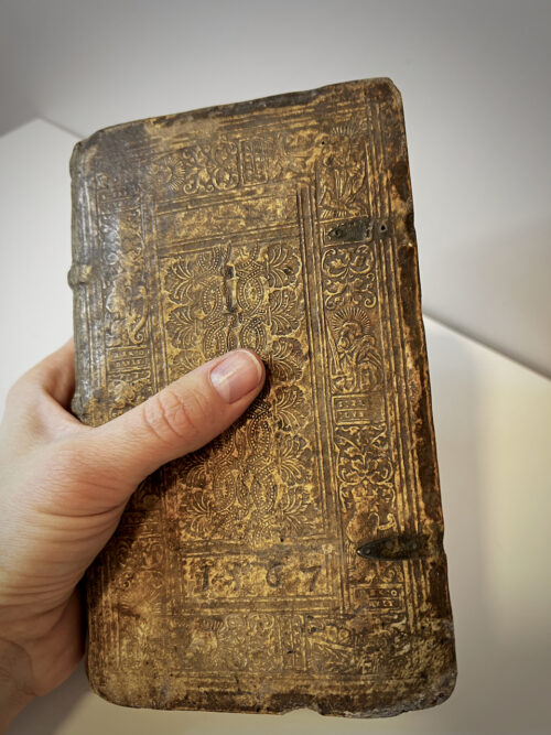 1564 Antique book M. T. CICERONIS DE OFFICIIS
2500 €
1564 Antique book M. T. CICERONIS DE OFFICIIS
2500 €
-
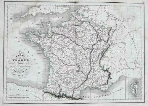 1858 Antique Map of France – "Carte de France"
180 €
1858 Antique Map of France – "Carte de France"
180 €
-
 Ludo Cosma (1934 - 2013) ''3 chiens au bateaux'' 1968, oil on canvas, 54 x 73cm
950 €
Ludo Cosma (1934 - 2013) ''3 chiens au bateaux'' 1968, oil on canvas, 54 x 73cm
950 €
-
 Alex Salaueu (1926 - 2021) ''Fashion show'', 1991, 61x43 cm
700 €
Alex Salaueu (1926 - 2021) ''Fashion show'', 1991, 61x43 cm
700 €
Reviews
There are no reviews yet.